
-
Home

- Weather Tower
Weather Tower
WINDS (Weather Information Network Display System) Tower
The current Eastern Range tower network has 46 towers including one 150 meter and three 62 meter towers. The towers cover an area of about 122 km for an average station density of one tower every 27 km. The identification numbers are based on location. The first two digits of the 4 digit ID (including a leading zero when necessary) correspond to the distance in nautical miles west of the coastline. The last two digits are the distance (n. mi.) north of Port Canaveral. Towers south of the Port have a leading digit of 9. Towers 511, 512 and 513 are located respectively at the south, center and north of the Shuttle Landing Facility.
Several towers are associated with launch complexes (LC) of the same number as follows: 17 (Delta II, SE shore of the Cape), 36 (Atlas, just north of the tip of the Cape), 40 and 41 (formerly Titan, now Atlas V and Falcon, north of #36) . LC 37 (Delta IV) is not shown but is between LC 36 and LC 40. Tower 398 on the map is located near LC39, the former Shuttle launch complex.
Wind speed and direction are measured with propeller vane anemometers with an accuracy of about 0.3 m/s and 3 ºC respectively. Air temperature is measured with platinum RTD sensors and RH with capacitance-type humidity sensors. Towers designated “launch critical” or “safety critical” are mechanically aspirated. The remaining towers are naturally aspirated. Temperature accuracy is better than 0.5 ºC RMS and RH accuracy is better than 3% RMS (Eastern Range Instrumentation Handbook, 2005). Measurements are collected at one second intervals and reported at five minute intervals. For each five minute interval the average wind speed and (vector average) wind direction as well as the one second peak wind speed and direction of that peak are reported. The temperature and RH values are 5 minute averages.
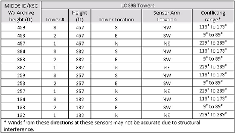
LC-39B Towers Weather Sensors
Within Launch Complex 39B (LC-39B), there are three lightning towers with sensors positioned at 4 heights on each tower.
These sensors capture wind speed, wind direction, temperature, and relative humidity. In order to fit the data into the
existing weather archive structure, it is necessary to identify each sensor using a reference height as a locator. For
example, the MIDDS ID on Tower 2 shown as 258 feet high, is actually 257 feet high.
 Search Weather Tower »
 View Large Map
 Download
Instrument List
Download
Instrument List
Notes
Some of the data may not be available online due to disk space limitations. If you need any of this data, please contact the curator of this website.