
-
Home

- Lightning
Lightning Reports
Merlin Cloud to Cloud Lightning System (MERLIN C-C)
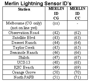
The Cape Mesoscale Eastern Range Lightning Information Network (MERLIN) detects and locates both Cloud-to-Ground (CG) and Intra-Cloud (IC) lightning. The system uses VHF interferometry to determine 2D locations of multiple sources associated with an IC lightning flash and LF magnetic direction and TOA finding to determine CG flash/stroke ground strike locations over and near the CCSFS and KSC. The system is used to ensure the safety of personnel and assets for launches and launch operations. The configured system includes ten Total Lightning Sensor (TLS)-200 sensors.
 Search MERLIN C-C »
Merlin Cloud to Ground Lightning System (MERLIN C-G)
The Cape Mesoscale Eastern Range Lightning Information Network (MERLIN) detects and locates both Cloud-to-Ground (CG) and Intra-Cloud (IC) lightning. The system uses VHF interferometry to determine 2D locations of multiple sources associated with an IC lightning flash and LF magnetic direction and TOA finding to determine CG flash/stroke ground strike locations over and near the CCSFS and KSC. The system is used to ensure the safety of personnel and assets for launches and launch operations. For CG ground strike detection and location, the system has been tested to a mean error of approximately 60 m over KSC with a 98.8%/92.2% detection efficiency for flashes/strokes. The configured system includes ten Total Lightning Sensor (TLS)-200 sensors.
Electric Field Mills (LPLWS)
The Launch Pad Lightning Warning System (LPLWS) is a large-area network of 31 electrostatic field sensors (field mills) that measures the vertical component of the electrostatic field, E, produced by cloud charges aloft, even if those clouds are not producing lightning. The sensors are termed ‘mills’ because they employ a rotating and grounded metallic shutter to alternately cover and uncover a set of insulated stators that respond to E. The amplitude and polarity of the current flowing to and from the stators is proportional to the amplitude and polarity of the local electric field. When an electrified cloud forms overhead or moves into the region, the E field will increase and often change polarity. In most cases, E will be large close to the cloud charges and small farther away, so 2-dimensional maps of E will show approximately where the cloud charges are located.
The LPLWS data is available in two forms: (1) The 50 Hertz (Hz) data is the raw electric potential gradient data. It is available under the “Raw Historical Data,” along with the executable file needed to extract the data and output it in ASCII format. (2) The 1-minute mean data is calculated within our archive using the search feature below or by submitting a “Data Request.” See the “Help” section for an important explanation about how the 1-minute mean is calculated.
Lightning Detection and Ranging (LDAR)
LDAR-II/4DLSS – This Lightning Detection and Ranging (4 Dimensional Lightning Surveillance System, 4DLSS) is an array of nine “time of arrival” sensors which enables meteorologists to analyze lightning events up to 100km in all directions from a central location at Kennedy Space Center. The LDAR sensors confirm an event based on the frequency generated for a lightning event. Step leaders and other in-cloud lightning mechanisms generate radio pulses. The difference in time of arrival of these radio pulses at pairs of LDAR-II sensors is used to calculate a hyperbolic volume. The intersection of four different hyperbolae locates the step leader in three dimensions. The nine LDAR-II sensors provide many possible locations for a single event. The best location of the step leader is solved via statistical Chi-Squared minimization.
Cloud to Ground Lightning System (CGLSS)
The Cloud-to-Ground Lightning Surveillance System (or CGLSS) utilizes a network of gated, broadband electric and magnetic field sensors (Krider and Noggle, 1975) to detect the waveform signatures that are characteristic of return strokes, the high-current components of CG flashes (Krider et al, 1976; Herrman et al., 1976). When a proper signature is detected (in the time-domain) at two or more known locations (the antenna sites), the coincident times-of-arrival and magnetic directions can be used to compute the points where return strokes strike the ground (Krider et al., 1980; Cummins et al., 1998; 2006).
 View Large Map

 Download
Instrument List
Download
Instrument List
Notes
Some of the data may not be available online due to disk space limitations. If you need any of this data, please contact the curator of this website.