- Home
- History
- Operational Examples
- Quarterly Reports
- Final Reports
- Journal Publications
- Conference Presentations
- Conference Posters
AMU Fact
A wildfire, the sea breeze and thunderstorm outflow boundaries resulted in a tornado at Kennedy Space Center in July 1995.
Two Columns
AMU Operational Examples - Radar and Outflow Boundary Detection
The AMU develops tools and techniques for customer's operational weather analysis and display systems.
Radar and Outflow Boundary Detection
The AMU staff develops solutions to work with customer's operational systems to include the Meteorological Interactive Data Display System (MIDDS) and the Advanced Weather Interactive Processing System (AWIPS). The AMU has also developed operational tools for customers to use with Microsoft® Excel© and web browsers.
The links below contain select examples of operational tools developed by the AMU for our customers.
| Radar and Outflow Boundary Detection | MIDDS and AWIPS Tools |
| Brush fire results in a tornado at KSC | Anvil Threat Sector |
| Objective Lightning Probability | |
| Excel-based Tool | Web-based Tool |
| Upper-level Winds Assessment | Climatology of Lightning Probability |
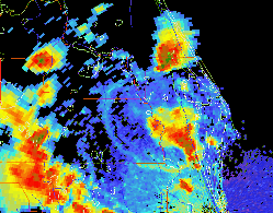
Radar and Outflow Boundary Detection
This loop of radar reflectivity illustrates the difficulty in
forecasting at KSC and CCAFS. It shows numerous complex boundary
interactions initiated by the sea breeze, thunderstorms and a brush
fire. These boundary interactions result in a tornado at KSC.
|