


Synthesis for June 15, 2001
There was quite a bit of lightning in this system until just before the aircraft arrived.
Summary for June 15, 2001
Investigator: (Jim Dye)
Lightning
ANALYSIS:
Between 1700 and 1730 a pair of cells NE of KSC near (-50,75) start producing both IC and CG lightning. This convection quickly intensifies and by 1730 the LDAR plots show almost continuous lightning. By 2000 (the time of the first radar plots) the storm has produced a stratiform region extending 75 or more km to the NE of the active cores. radar_1958_7km The main core is to the SW of the complex with reflectivities exceeding 55 dBZ at 10 km. The stratiform regions extends from at least 4 km to above 10 km and probably has precip to the surface. Between 1900 and 1930 lightning begins to extend into this stratiform region producing large areas with lightning.
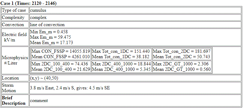
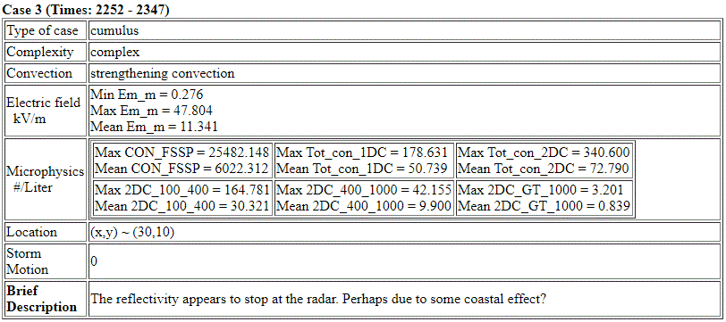
Case 1:
At the time of takeoff near 2115 UTC there was an arm of stratiform debris extending 125 km to the NE. This debris had considerable shear to the SE especially between 7 and 10 km but also some displacement between the 4km level (which had patches of 35 to 40 dBZ) and 7 km (which had very small patches of 25-30 dBZ). Reflectivities were weaker at 10 km. (~ 15-20 dBZ). After takeoff the Citation flew to the NE climbing in this arm of stratiform debris with the track near the axis of the reflectivity at 4 km.
Ez showed moderate values during the climb until about 2128 when they increased to ~+20 kV/m at –1C (~4.5 km), then shortly after reversed polarity with –50 kV/m by 2130. Reflectivity above at and below the A/C were 20 to 40 dBZ. The Citation, now at ~8 km, turned 2137 –2138 in reflectivities of 10-15 dBZ with Ez near zero. to return to the SW. This pass was centered more along the axis of the reflectivity at 7 km. Ez had moderate values of 5 to10 kV/m even though reflectivities just below the A/C were 30 dBZ or more most of the time. As the A/C got closer to the core near 2144 Ez increased in magnitude to –30 kV/m by 2145:30, then switched polarity to +20 kV/m by 2147.
Near 2148 the A/C turned to begin another pass to the NE again along the axis of the reflectivity arm at ~ 8km (-25C). This showed similar features to the 2138-2148 pass but Ez and reflectivities were somewhat less. Both small and large particles tended to decrease as the A/C flew toward the NE end of the arm. Another pass to the SW was flown from 2156 to 2204, again along the axis of max reflectivity at ~8km. By this time there was more horiz separation between the 4 and 7 km levels. I have the impression that the arm of debris was pushed out by the very active convection earlier between 1900 and 2000. As the main core weakened and was undercut by the long line approaching from the West, this arm of debris drifted with the wind at the different altitudes as it decayed in both E fields, particles and reflectivity. By 2220 the strongest Emag was ~8 kV/m for a brief period. After that the E fields were weak in this debris cloud
From 2221 until the Citation left this drifting debris slightly after 2245, Emag was no more than 1-2kV/m (including offset) at the A/C altitude. By this time the debris at 7 to 10 km had drifted ~30 to 40 km from the debris at 4 km.
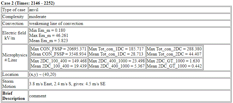
Case 2: Stratiform Region Associated with Line Moving from the West
At ~2250 the Citation moved west to investigate this separate stratiform region. The western part of the A/C passes through this region consistently showed strong E fields until the Citation left to return to PAFB.
In the two MER plots below as well as others afterwards, NOTE THE VOID IN RADAR COVERAGE IN A CONE ABOVE PAFB (see the hor plot) results in a region on the right side of MER 2252 with no apparent reflectivity but many particles and beginning of high E fields. In MER 2300 on the left side you can actually see the inverted cone of the radar void.
SUMMARY:
A region of very active convection NW of KSC with copious lightning produces a stratiform region probably extending from the surface to above 10 km to the NE of the storm cores. The Citation taking off near 2115 climbs out in this stratiform arm or region. There is considerable shear between low and mid and upper levels, resulting in an anvil-like structure extending to the SE with weaker reflectivities at upper levels. By about 2200 the convection from these original cores is weakened and then cut off by a long line of intense convectve cells moving from the West and the lightning in the stratiform region ceases. But there is copious lightning in the line moving from the West.
The debris of this stratiform arm drifts to the SE and the Citation follows this debris as both the reflectivity, microphysics and E fields decay. By the time the Citation leaves this debris near 2250, the E fields have become quite weak and the largest reflectivities are 10 to 15 dBZ.
Even in the early and mid stage of the Citation investigations with lightning still occurring in this system, when the A/C was at the NE extent of the stratiform arm or debris the E fields were weak in reflectivities of 15 to 20 dBZ. In the investigation of Case 1 of drifting anvil-like debris, no instances were seen in which there were strong E fields but weak reflectivity, i.e. <10 dBZ.
This first Case of the A/C study is a good case to compare E fields with reflectivity and following the decay of the electric field to weak fields. But it is hard to quantify the time to decay because it is hard to identify the time of the last lightning in either the stratiform region and especially in the cores of the cells. It appears to be aproximately 2200. Some lightning does occur in the stratiform arm between 2115 and 2130 as the Citation climbs out to the NE.
From looking at the reflectivity patterns and the location of radar cores relative to PAFB, there was no apparent radar attenuation in the areas in which the Citation worked. However, it is quite likely that there was attenuation to the NW of the early very strong convection and also to the west of the long line of convection.
The MER plots for Case 2 clearly show effects of the INVERTED CONE of VOID in the RADAR DATA.
END OF SYNTHESIS