


Synthesis for June 6, 2001

There was heavy lightning in these cells before the aircraft, but was mostly gone when the aircraft was there. The motion is hard to determine. The animation leaves you to think it is moving, but the individual cells don't seem to go anywhere.
Summary for June 6, 2001
Investigator: (Natalie Murray and Jim Dye)
Summary
Two separate systems can be considered for this flight. Two decaying debris clouds were sampled from 18:20 until 20:00. There were several examples of high electric fields (+/-5 kV/m) which was usually accompanied by particle concentrations near threshold values mentioned above for the total 2D-C and FSSP. The presence of large particles (larger than 1000 micrometers) was also found to be important in the region of elevated the fields. A convective cloud was also sampled. The vertical electric field associated with the deep convective region reached -40 kV/m. The total FSSP concentration was greater than 10^4 (#/cc) while the total 2D-C remained at 10^2 (#/L) and the large particle concentration remained below 1 (#/L) as measured by the HVPS. Ground based potential gradient measurements were also made near the convective cloud. The field at the ground was positive.
Generally, the vertical electric field was elevated only when supported by regions of radar reflectivity was above 5 dBZ with higher dBZ values in the immediate vacinity. At no time in the flight did the vertical electric field deviate from zero by 5 kV/m without radar reflectivity greater than 5 dBZ along the flight path and higher dBZ values were present above or below the flight path.
Radar
Overview: Initially there is convective development W and NW of KSC that moves NE. The aircraft launched at 17:40 and headed NNW towards dying convection along the coastline. The flight path in the first 30 minutes was NNW of KSC near convective cells. At 18:20 the citation moves east and completes several N-S cross-sections in the stratiform region of a decaying debris cloud. The last lightning flash associated with this cloud was at 18:05. The cloud is sampled until 19:20. The aircraft then heads northward to a similar stratiform region and continues the N-S cross-section. The aircraft turns southwest at 20:00 to intercept a convective system to the west of KSC and overpasses the GBFM team at 20:15. The aircraft lands at 20:30.
Two systems to consider from this day:
1) decaying debris cloud (18:20 - 19:20 and 19:20 - 19:55)
2) convective cloud (20:10 - 20:20)
MER Plots
Decaying Debris Cloud:
A) 18:20 - 19:20 Aircraft flight path in N-S cross-sections north of KSC along coastline sampling weakening stratiform region. Initially there was a layer of 20-35 dBZ reflectivity below 8 km. Generally the electric field deviates from zero when the particle concentration is near threshold values total 2D-C concentration of 10^2 (#/L) and FSSP concentration of 10^4 (#/cc). The presence of large particles also seems to be important, however there are no clear threshold values. The following times are examples of when the vertical electric field deviated from zero and a description of the microphysics and radar at that time.
18:18:30 - 18:21 (peak of -15 kV/m at 18:19)
Microphysics: At the time of peak in electric field; the total FSSP and 2D-C near threshold and large particles present.
Particle concentration decreases after peak and mimics the electric field return to zero.
Radar: Flight path through 10 to 20 dBZ during peak in electric field. Later pass was above cloud top and higher reflectivity.
18:27 - 18:29 (peak of -10 kV/m at 18:28)
Microphysics: Concentrations approaching threshold mentioned above. There are large particles present.
Radar: Aircraft just above layer of 20-35 dBZ reflectivity and -5 to 20 dBZ region extends 3 km above flight level.
18:29:30 - 18:31:30 (peak of -5 kV/m at 18:30:10)
Microphysics: HVPS shows presence of particles larger than 1000 micrometers. However, the larger particles are not seen by the 2D-C. Concentrations of the smaller particles near threshold values.
Radar: Generally the same as situation mentioned above. Some evidence that the region is weakening.
18:35:40 - 18:39 (-15 kV/m) Note: Aircraft bank angle
Microphysics: Same as mentioned above, however less large particles present.
Radar: Generally the same as other times. Evidence of bright band at 4-5 km.
After 18:40 the stratiform region decreases in intensity and size significantly. The vertical electric field deviates slightly from zero at 18:50-18:53 but does not exceed -5 kV/m.
B) 19:20 - 19:55 Aircraft heads north into another stratiform region. Regions of reflectivity above 25 - 35 dBZ extend from 3 to 7 km and above 5 dBZ up to 13 km. As with the previous debris cloud, the electric fields are elevated when the particle concentrations are near threshold values and when radar reflectivity is above 5 dBZ along the flight path and higher in regions above or below flight level. During this part of the flight the aircraft is flying through regions of 20-25 dBZ reflectivity. Within these regions there are strong electric fields as seen in the times listed below.
19:23 - 19:26 (-15 kV/m)
19:27:30 - 19:31:30 (+10 kV/m to -10 kV/m) Aircraft banking.
19:39 - 19:41 (+20 to -5 kV/m)
19:52 - 19:54 (-5 to +5 kV/m) Aircraft begins banking when polarity in electric field changes.
The microphysics in each of these periods of elevated fields is consistent with the observations stated above for the other debris cloud case. However, in this case there were always large particles present (as seen from the 2D-C) whenever fields were high.
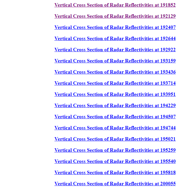
Below are links to the vertical cross sections of the radar data for this debris cloud. The horizontal coordinate system has been rotated such that the y axis is parallel with the coast line. An effort was made to identify the center line of the cloud and only the cross section for that line is shown. For further information on the geographic location please refer to the horizontal plots.
Convective Cloud:
Aircraft headed home, flies south through the cloud and then east to PAFB. Banking from 20:15 to 20:16 and descending from 6 km to 4 km.
MER plot filename time: 201640
Time range: from 20:11:25 through 20:19:18
Approximate times for volume scan:
1) 20:11:25 - 20:14
2) 20:14 - 20:16:40
3) 20:16:40 - 20:19:18
Volume scans 1 and 2 show deep convective clouds. Volume scan 3 no cloud is present in radar or microphysics.
Volume scan 1, microphysics show presence of large and small particles. Two pockets of 30-40 dBZ values within 1 - 6 km. Otherwise -10 to 20 dBZ found from 1 km to 11 km. Electric fields deviate from zero at 20:12 - 20:13:30 at the same time as increase in particle concentration.
During volume scan 2, microphysics show high concentrations of small particles (FSSP > 10^4 #/cc), total 2DC near 10^2 (#/L), and 0.1 to 1 particles per liter larger than 1000 micrometers. The elevated number of small particles suggests cloud droplets present in this region and were likely placed there by a transport process (updraft) from another region of the cloud. Also it is likely that super-cooled water droplets are also present (no observations to support this claim). In the first 3/4 of the volume scan there are several layers of reflectivity.
Layers: 40 - 50 dBZ from 1 km to 5 km
25 - 35 dBZ from 5 km to 8 km (some into 9 km)
cloud top heights extending to 13-14 km
Electric field drops to a significant negative value (-40kV/m) from 20:14:30 to 20:16:10 and returns to zero quickly. This is evidence that the charge region is small. Note: this is also during the time the aircraft is banking. Microphysics data ends at 20:16:50 while still in dBZ values of -10 to 15.
For volume scan 3, no particles and no fields
LDAR 20:10 to 20:20
Electric Fields aloft at 20:13 to 20:18
GBFM:
Fields (measured in potential gradient) switch from negative to positive, crossing zero at 20:12. Maximum field value of 3.4 kV/m around 20:15:50 - 20:15:10 and decreasing again and crossing zero at 20:27. GBFM taking data at 28 27.2N 80 58.8W (25 km West from aircraft track). Ground observations include: ability to see the sun through the clouds, little to no precipitation (video and pictures available).
Ground Based Field Mill 1900 - 2030
Ground Based Field Mill 2000 - 2030
Summary
Two separate systems can be considered for this flight. Two decaying debris clouds were sampled from 18:20 until 20:00. There were several examples of high electric fields (+/-5 kV/m) which was usually accompanied by particle concentrations near threshold values mentioned above for the total 2D-C and FSSP. The presence of large particles (larger than 1000 micrometers) was also found to be important in the region of elevated the fields. A convective cloud was also sampled. The vertical electric field associated with the deep convective region reached -40 kV/m. The total FSSP concentration was greater than 10^4 (#/cc) while the total 2D-C remained at 10^2 (#/L) and the large particle concentration remained below 1 (#/L) as measured by the HVPS. Ground based potential gradient measurements were also made near the convective cloud. The field at the ground was positive.
Generally, the vertical electric field was elevated only when supported by regions of radar reflectivity was above 5 dBZ with higher dBZ values in the immediate vacinity. At no time in the flight did the vertical electric field deviate from zero by 5 kV/m without radar reflectivity greater than 5 dBZ along the flight path and higher dBZ values were present above or below the flight path.