


Synthesis for June 2, 2001
Summary for June 2, 2001
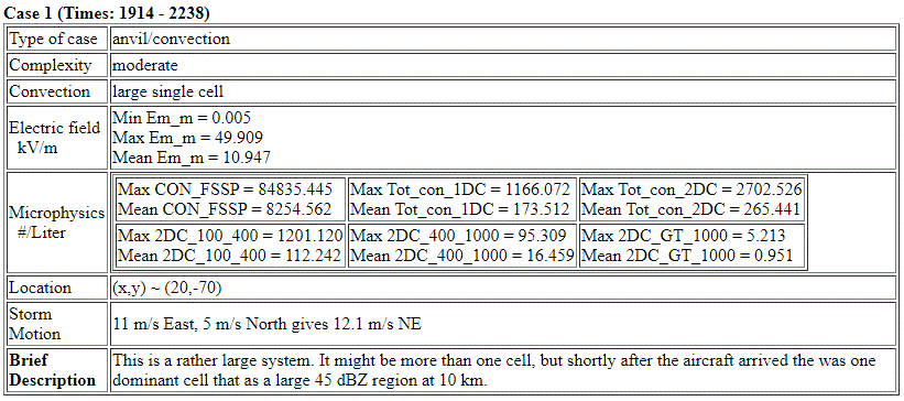
Investigator: (A. Grainger)
SUMMARY (by J. Dye)
The first sporadic lightning on this case starts at roughly 1750 to 1800 about 1 1/2 hours before the Citation starts it's investigation. The last LDAR sources are detected at roughly 2245 just as the Citation leaves the storm. Throughout the A/C studies there was copious lightning and the Citation was frequently near it and it was seen inside the A/C.
Most of the A/C study shows the Citation was frequently in regions with high E fields. For most of the measurements between 1930 and 2030 the A/C was flying in a region with serious radar attenuation. From ~2040 the A/C flew mostly in a stratiform region to the SW of the main storm core . During this period to the end of the flight attenuation should have been less of a problem. In the stratiform cloud the MER plots show that at the edges of the region the reflectivities were less and the E fields became weak, both on the W and E edges of the system. But in the larger, main body of the stratiform region reflectivities at or below the A/C were 20 to 30 dBZ and the E fields were strong (10 to 50 kV/m). This part of the flight has some value for looking at E field in relationship to reflectivity and the edges of the system appear to be anvil-like. Two pairs of spiral ascents followed by descents were made in the stratiform region.
In summary, the importance of attenuation of the radar signal is clearly important if the radar is to be used as the primary decision-making tool. While this was not the best case upon which to be drawing conclusions regarding relationship between strong E fields and reflectivity, there was a tendency for the high electric fields to be associated with the thick portions of the cloud mass.
Flight of June 2, 2001
This mission was characterized by high electric fields and lightning often near the aircraft. The flight track shows that the bulk of the measurements were taken to the SSW of Patrick, Just off the coast. The lightning began shortly after 1600 and the activity continued to increase until after the Citation took off at 1846.
Lightning
Lightning Image Directory
At this point, there were spiral descents and ascents beginning at 2052.
Looking at the radar, the cells in the area were quite intense and continued to be strong throughout the majority of the mission. For a significant fraction of the flight, radar beam attenuation would have been significant. The shadowing behind the higher reflectivities is quite apparent in some of the CAPPIs. As luck would have it, a fair amount of the time that the Citation.
Looking at the MER plots, the first pass was made.

Then we have the area of less than 10 dBZ with high field strengths. This is in the attenuation region, due to the strong cell to the north of where the Citation was flying.

The motion of the cells was roughly eastward throughout the mission. The electric field was highly variable from place to place in the cloud and we were not flying the same track consistently, as was evident from the flight tracks. However, a cursory scan of the following will give a flavor of the behavior of the fields in the cloud.

It should be noted that the characterization of the cloud that we were flying through, while we called it an anvil in real-time, does not appear to be what would normally be referred to as an anvil in many parts of the cloud. Note that on this leg, the radar return goes down to the lowest detectable elevation.

At about 2052, we started a spiral descent through a portion of the cloud that we had been flying through. The descent rate was about 1000 ft/min. Lightning was visible on several occasions during the descent.

We then began a climb back up to 31,000 ft, moving a bit further away from the main part of the storm.

At about 2119, we began another spiral descent. This part of the cloud looked more like what we would call anvil.

We then started a spiral ascent in the same general area.

In summary, the importance of attenuation of the radar signal is clearly important if the radar is to be used as the primary decision-making tool. While this was not the best case upon which to be drawing conclusions, there was a tendency for the high electric fields to be associated with the thick portions of the cloud mass.