


Synthesis for May 25, 2001
The various "cases" for this flight were all associated with the same line of convectin. It is susspected that each had a separate core. Or, as in the case of 1 and 5 or 2 and 4 the aircraft sampled the same "cell system" at different times.
The velocity was the velocity of the system which didn't really go anywhere. The cells moved very slowly, while the anvils developed and blew off to the NE. There was some motion within the line, but the line didn't really move. It was difficult to distinguish between storm motion and the growth and development of the anvils that formed.
There was lightning in the cores that increased as the anvils developed, then was very light in the region studied (cases 1-5) when the aircraft was there. Case 6 did still have lightning occurring while the aircraft was nearby.
Summary for May 25, 2001
Investigator: (Phil Krider and Natalie Murray)
The A/C launched at 18:38 and landed at 2213 UTC. Due to ATC restrictions the A/C could not sample the best regions within the anvils and there were many times when the A/C sampled clear air.
Two separate cases were observed during this flight. The first (18:50 - 20:20 UTC) sampled an attached anvil with a quickly decaying core that subsequently became a debris cloud. Most of this portion of the flight is over the water. Until 18:58 the A/C location was logged as being at PAFB. This is clearly a mistake and explains the absence of radar return during high electric fields. During the interval 19:29:04 - 19:37:35 the aircraft left the anvil/debris cloud and sampled the west side of a convective cell over land. The region sampled was more like a trailing stratiform region, but was very localized. The A/C was in close proximity to active light and elevated fields were not observed. The 2DC was not working during this time. The A/C then returned to the region it was sampling prior to the detour.
The second case (20:20 - 22:00 UTC) was an attached anvil from several active (and weakening) cores. This segment of the flight was over and near the KSC area. During the interval of 20:49 - 20:59 there is no electric field data. There was lightning activity in the vicinity of the A/C during this case. There may be several examples of lightning field changes aloft over or near the KSC network, and one interval in particular is from 21:08:30 - 21:10:30. The A/C fields are elevated and a lightning field change occurs at 20:09:20; at this time the A/C was over water east of KSC. Two surface field mills (site 13 and 28) from the KSC network showed field changes of approximately 20 - 40 V/m. In a later portion of this flight, the A/C was in a region of radar void. Elevated fields were observed between 21:46:27 - 21:47:10 and 21:49:40 - 21:50:10 without clouds as detected by radar. For these times, we will need to examine NEXRAD radar data.
Elevated fields were observed in both cases, and there were several intervals in which the E-fields were significant and a cloud was not detected by the Patrick radar. During these events, the microphysical instruments show the presence of cloud along the flight track; therefore, we presume these events are within radar voids.
Two separate cases were observed during this flight. The first sampled an attached anvil with a quickly decaying core that subsequently became a debris cloud. Most of this portion of the flight is over the water. The second case was an attached anvil from several active (and weakening) cores. This segment of the flight was over and near the KSC area.
Elevated fields were observed in both cases. There were several intervals during which the electric fields were significant and a cloud was not detected by the radar. During these events, the microphysical instruments showed the presence of cloud along the flight track. Most of these events appeared to be within a radar void.
Due to ATC restrictions the A/C could not sample the best regions within the anvils and there were many times when the A/C sampled clear air.
Web location of the total flight track
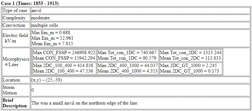
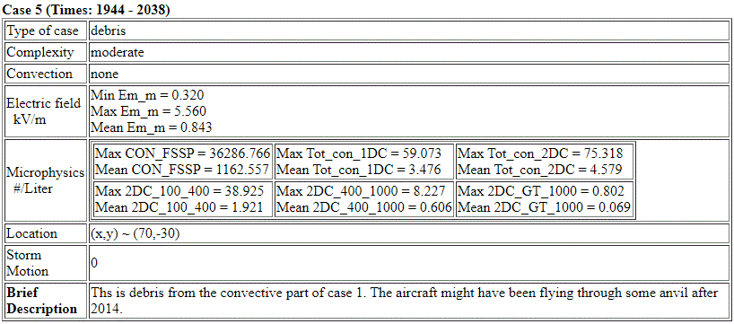
Case 1: Attached anvil turned debris cloud (1853 - 2030)
During the following time periods 185028 - 192904 and 193735 - 201937 the A/C was sampling an anvil that decayed into a debris cloud. The A/C was mostly over the water.
Points of Interest
MER plot for 185250 - 190042
18:52 - 18:58 Elevated and complex electric fields prior to the A/C entering a cloud region as determined by radar. The microphysics does however indicate that there was a cloud present. After 1858 the cloud is seen by the radar and there are elevated fields (+/- 20 kV/m with a polarity charge) At this time there is no aircraft track information and thus the radar reflectivity could not be displayed.
MER plot for 190042 - 190836
19:00 - 19:03 elevated fields ~5-10 kV/m
19:03 - 19:08 A/C track in lowest layer of or below cloud
no elevated fields
MER plot for 190836 - 191630
A/C in lower portion of the cloud
Fields slightly non- zero
MER plot for 191630 - 192426
A/C track generally through the middle of the cloud
19:20:50 - 19:21:10 Fields deviate from zero >-10 kV/m
MER plot for 193219 - 194012
During the interval 19:29:04 - 19:37:35 the aircraft went around the backside of an active convective cell over land. The region sampled was more like a trailing stratiform region, but was very localized. No elevated electric fields sampled. Only the FSSP detected particles.
MER plot for 194012 - 194805
At 19:45 A/C descended from 7km to 5 km through a small cloud. 19:46:20 - 19:47:30 electric fields were elevated -/+ 10 kV/m with a polarity change.
For the remainder of the case (until ~20:20) the A/C was mainly beneath the weakening debris cloud and no elevated electric fields were observed.
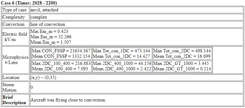
Case 2: Complex attached anvil(s) (2034-2211)
Points of Interest:
There was lightning activity in the vicinity of the A/C during this case. There may be several examples of lightning field changes aloft over or near the KSC network. It would be beneficial to look at the A/C field in a faster time resolution along with the surface fields.
No electric field data 20:49:40 - 20:59:40
MER plot for 205906 - 210658
A/C through regions of broken cloud
21:03 - 21:04 Electric fields at -10 to -15 kV/m
MER plot for 210658 - 211452
21:08:30 - 21:10:30 Elevated Electric Fields
Large positive field ~ 35 to 40 kV/m
Then a polarity change to near -25 kV/m
High concentrations were present for all cloud particles.
Lightning field change observed at 21:09:20
MER plot for 211452 - 212245
21:15 - 21:16 fields at -10 to -15 kV/m with a slight return in the positive fields. A/C track through a thin but reflective (10 to 25 dBZ) portion of the cloud.
MER plot for 214627 - 215149
21:46:27 - 21:47:10 and 21:49:40 - 21:50:10 elevated electric fields (approximately -20 to -15 kV/m) without a cloud present. Microphysical measurements indicate of a cloud present. On radar the cloud was below the flight track.
MER plot for 21:54:19 - 22:02:13
21:54:19 - 21:55:10 elevated electric fields (-10 kV/m). A/C track was slightly above the cloud as determined by radar.
The other time intervals do not have elevated fields.