


Synthesis for June 17, 2000
This is probably an example of Debris, but possibly also a Thick Cloud.
The horizontal extent was a maximum of ~50 km with layer from 4 to 10 km with some patches of reflectivity reaching ground. The aircraft studied a SW end of a line going SW to NE. The area just SE of KSC had convection at 1400 which moved onshore. The cloud that was studied was "left behind" with new stronger convection forming to the NNE. The area over KSC had reflectivities of ~25 dBZ until 1600 at 7 km. The "Storm Motion" given above is the motion of the line.
Summary for June 17, 2000
Investigator: (None)
The following summary is from the notes that Jim Dye and Eric Defer put together. Probably early in 2001 (before the May/June 2001 Field Campaign).
E fields reported in the summaries below are based on the old matrix for determination of the three components of the field. The new matrix provided in April 2001 reduces the negative values of Ez as much as 40 to 60%. So the values reported herein may be too large. Positions are reported herein as (X,Y) coordinates relative to the WSR74-C radar.
The total concentrations of particles measured by the 2D-C probe are denoted as N30 (ie. concentration of particles >30 microns which is heavily weighted towards smaller particles). N1 refers to the concentration of particles >1mm size, ie. the larger particles. Radar plots were available for only a few of the last summaries we prepared (June 4, 6, and 11). For other days some of the realtime radar plots were utilized but need to be verified.
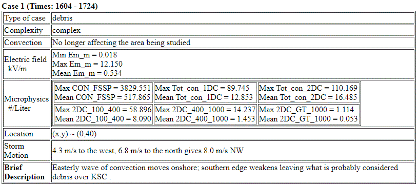
June 17
A small maritime storm just to the east of KSC produced 3 CG flashes from1405 to 1417. At this time it had radar tops to 14 km with 35 dBZ extending to 9 km. There were two other somewhat smaller cells to the west and southwest of the cell with lightning that also contained reflectivities of 50 dBZ at low altitudes but weaker aloft. The NW cell did reach ~13 km radar tops but apparently produced no lightning. Then the cell with lightning collapsed although there may have been some convective bubbles within the decaying cell. The residual at 6 to 8 km from this cell slowly drifted to the west and merged with the cell to the west and by the time the aircraft arrived, it was hard to distinguish one from another.
These remnants drifted over the surface field mill network and between very roughly 1520 [CHECK] to 1600 produced elevated fields up to +3500 V at field mill site 26 at 1539.
The aircraft took off at 1600 and shortly after takeoff while still climbing from 5 to 6 km, it flew just below the eastern edge of some of the debris at ~ 1608 to 1610 but no discernable enhancements of Ez were detected. Radar shows main area of debris a little west of the Citation position. The plane climbed to 9.4 km and while making a pass from 1626 to 1629 through the top part of the debris, observing Ez of ~ +1.5 KV/m. On later lower passes at 1646 to 1651 and 1653 to 1658 at 7.5 km Ez fields of 3 to 3.5 KV/m were observed. Total 2D concentrations were < 100 /L and particles > 1mm size were ~0.1 to 0.2 /L.
This is a good case showing that by 2 to 2 ½ hours after lightning field strengths had decayed to a maximum of about 3 KV/m. More work can be done to examine the maximum reflectivities below the A/C for the different passes and compare to reflectivity over the surface network when it was showing enhanced positive fields. A rough early comparison suggests reflectivities over the surface network were ~25 dBZ, but by the aircraft arrived they had decayed to ~15 dBZ.