


Synthesis for June 12, 2000
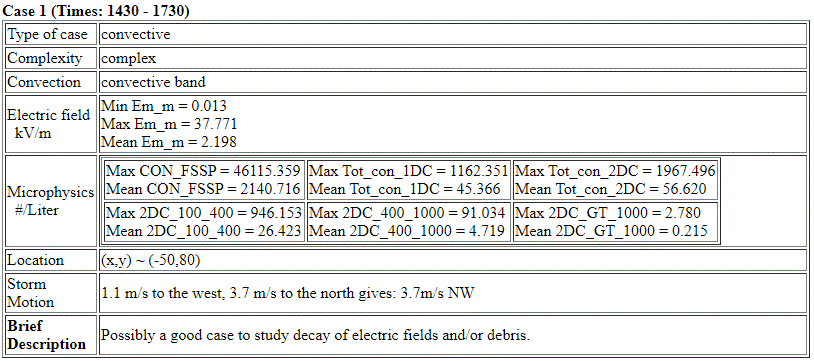
Case 1: When the cappi loop is run this starts out as a single cell, but it "breaks up", just before the aircraft gets there, into several separate pieces. Lightning occurs during the flight. Although this would not be good for electrical initiation (aircraft gets there too late), nor for anvil studies, it might be good for electrical decay. Cloud tops are above 10 km with active lightning while the aircraft flies through the primary cell.
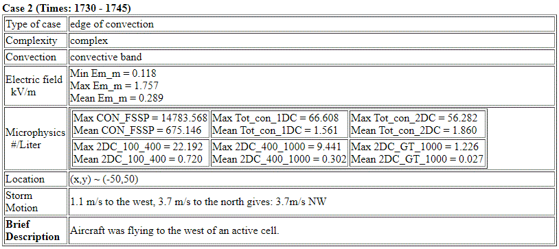
Case 2: Aircraft was flying to the west of an active cell.
Summary for June 12, 2000
Investigator: (None)
The following summary is from the notes that Jim Dye and Eric Defer put together. Probably early in 2001 (before the May/June 2001 Field Campaign).
prepared by Jim Dye with help from Eric Defer
E fields reported in the summaries below are based on the old matrix for determination of the three components of the field. The new matrix provided in April 2001 reduces the negative values of Ez as much as 40 to 60%. So the values reported herein may be too large. Positions are reported herein as (X,Y) coordinates relative to the WSR74-C radar.
The total concentrations of particles measured by the 2D-C probe are denoted as N30 (ie. concentration of particles >30 microns which is heavily weighted towards smaller particles). N1 refers to the concentration of particles >1mm size, ie. the larger particles. Radar plots were available for only a few of the last summaries we prepared (June 4, 6, and 11). For other days some of the realtime radar plots were utilized but need to be verified.
June 12
The Citation flight was from 1425—1755 with passes primarily at 7.9 km (-24C). It first investigated a small storm south of Daytona Beach at (-50,80) with 6 or 7 flashes (3 or 4 CGs) from 1433 to 1456. Another bigger storm developed to the SW with first lightning at ~1535 as A/C working first storm, but too active to work and couldn’t get clearance. First pass at 1450 shows Ez to –40 KV/m. Successive passes until 1607 show Ez >15 KV/m often as large as 40 to 60 KV/m (e.g. 1548 and 1553) even though no lightning after 1456. A/C continued passes until ~1725. Ez after 1630 <few KV/m and probably <1KV/m by 1700.
N30 = 200 –1000 /L until 1610 with N1 ~ 0.5 –1 /L. After 1615 N30 usually 100 /L or less and N1 ~ 0.1 to 1/L. After 1700 N30 ~50/L or less and N1 0.05 to0.5 /L. Realtime radar plots suggest radar tops in excess of 30,000 ft with 40 dBZ to 20,000 ft near 1530, but need to verify this. Last realtime RHI at 1637 suggests 20dBZ max at this time. Appears to be a case with weak updrafts which did produce lightning early on and continued to have charge separation occurring until ~1600-1605 with updrafts dying afterwards. May be interesting to look at Doppler data from 74C for hints of updraft strength.
CHECK: How well does radar show evidence of weak, but continued convection during the period with enhanced Ez and probable threat?