


Synthesis for June 11, 2000
This summary differs from that written before, because I no longer believe these are debris cases and I have broken the original "case 1" into 2 cases. (Nov 19, 2003)
There were several separate cells that some of which produced lightning and some did not. They were all moving at a uniform velocity towards the north-west.
Summary for June 11, 2000
Investigator: (S. Lewis)
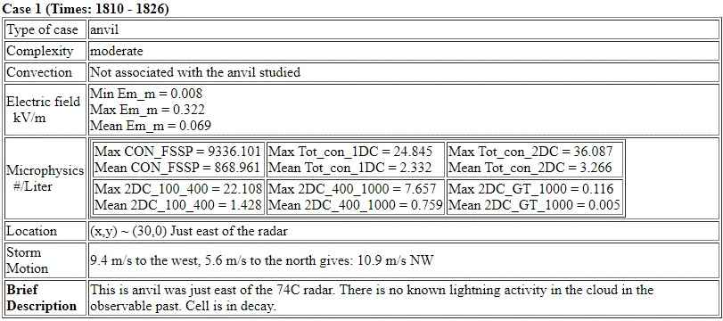
CASE 1 : 1810 - 1900)
Prior to the Citation's take off at about 1810, convection to the west of KSC produced lightning from roughly 1600 to 1700. There were more active cells NW of the storm which the Citation investigated. The main storm of interest had one cell near (-25,-50) which had produced several CGs as well as activity on LDAR from ~1600 to ~1640. Another cell near (-30,-30) also showed LDAR activity suggesting a few IC flashes from 1655 - 1705 but probably no CGs.
The last CG lightning in the storm system that the aircraft flew through at 18:45 occurred at 16:27 and the last (non)CG lightning occurred at 17:05. There was still lightning activity in a system that was just to the west until 17:53.
Looking at either the individual radar images or using the Radar applet below between 1600 and 1900 it should be noted that the system the aircraft flew through falls under the case type of decayed convection. At 1845 it appears to be an anvil with the core at (-75, -10). When we look at the earlier radar volumes we find that the entire band showed convection (1800).
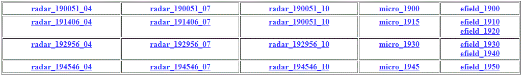
Lightning
Lightning Image Directory
Comparing the 4km, 7km, and 10km radar images shows a horizontal velocity gradient. The motion of the storm is from the SE. At the 4 km level it appears to be moving faster than at the 10 km level.
From ~1844 to ~1905 the particle probe outputs shows the plane was in weak reflectivity region at 8 km but on the eastern most edge for about 50 km in the N-S direction. Comparison of track with radar plots shows that deepest penetration into this region was from ~1849 to 1852 barely in 5 to 10 dBZ. [mer_1845] At this time the largest reflectivities were in a core region to the west and were 10-15 dBZ. E fields during all of the above period were very weak < 500 V/m. Most of this entire period the 2D-C shows no particles >1 mm, except perhaps for the 1849 to 1852 period. During this period the 2D-C was not operating.


Cross sections show the echo to go to the ground at 1845. The echo reaching the ground is indicative of precipitation. Given the earlier convection I would classify this time as the end of the convective cycle. Rotating the radar images in order to look and the "along line" or "perpendicular" directions we can see better (X=-12) the tilt in the vertical between the 4 km and the 10 km. We can also see that the echo pattern along the line towards the NE is not an anvil.
Rotated 27 degrees from the North

Summary of the first cell on June 11, 2000
The Citation found no enhanced E fields 1 ½ to 2 hours after the last lightning. The Citation flew close to decaying convective debris.
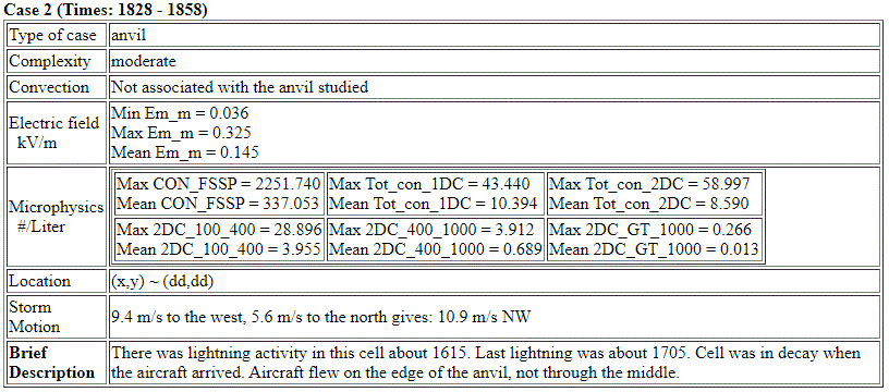
CASE 2 : 1901 - 1955
At ~1905 the Citation proceeded to a storm to the SSE of KSC near Vero Beach with anvil coming off to the north. Neither the LDAR nor the CGLSS detected any lightning from this complex which covered an area >50 x 50 km square with a number of cells.
Convection was weak to moderate moving in from the SE. At 1829 the radar shows this area is mostly convective with a bit of anvil blowing off to the north at about (-80, 50). Max reflectivities at 1900 were about 40 dBZ with radar tops extended to 12 km. Regions of weak E fields with a max of ~ 2 KV/m were observed along parts of the northern edge of this complex from 1910 to 1945. No significant fields were observed. Maximum reflectivities flown through were probably 0 to 10 dBZ near 1925, with reflectivities up to 35 -40 dBZ at 4 km below the aircraft. [mer_1916]
Cross sections show reflectivity going to the ground, and at X = +16 the peak reflectivity was 41 dBz
Cross Sections

Summary of the second cell on June 11, 2000
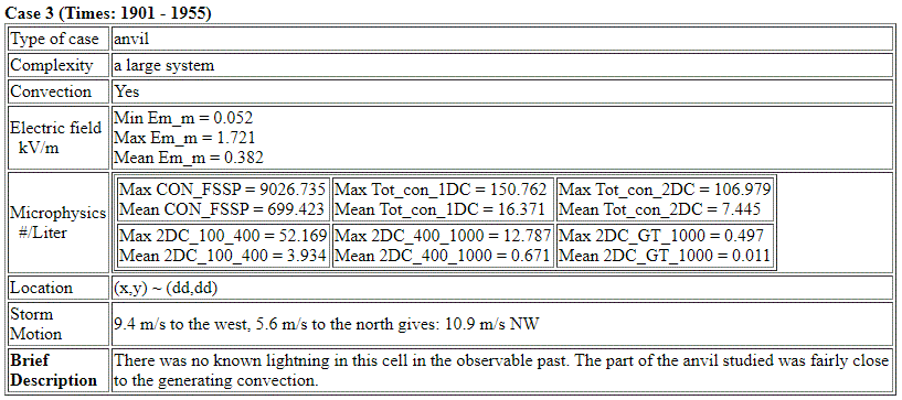
This case is interesting as a null case. It had higher reflectivities at lower levels and cloud tops reaching 12 km. There were no significantly enhanced fields and no lightning was observed.