


Synthesis for June 4, 2000
The summary is sufficient. I will repeat one sentence here:
Several penetrations of cloud boundaries were observed (during Case 1) that might be useful in the study of the decay of fields with distance from cloud edge.
Summary for June 4, 2000
Investigator: (F. Merceret and J. Ward)
(Presented with Jennifer Ward)
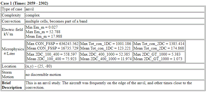
The aircraft flew descending vertical spiral and racetrack patterns through anvils blowing off to the east from a complex of thunderstorms between 50 and 100 Km south of Patrick AFB from 21 to 23Z. These storms formed in a well-defined tongue of cold air aloft that included a local 200 mb cyclonic circulation in the vicinity of Lake Okeechobee. The anvils generally exhibited high fields throughout the period, but the aircraft penetrated some regions of highly variable or minimal fields possibly associated with the presence of charge pockets or screening layers. Several penetrations of cloud boundaries were observed that might be useful in the study of the decay of fields with distance from cloud edge.
Run1 – spiral ascent 8 to 11 Km – 2104 to 2120: A tight spiral was centered near location X=+10, Y= -75 on the north side of active convection. Cores with more than 50 dBZ reflectivity at 4 Km altitude decreasing to 35 dBz at 10 Km were located about 25 Km southwest of the center of the spiral. The radar edge of the cloud was located just north of the northern edge of the flight track at 8 Km, just south of the southern edge of the flight track at 4 Km and about 5 Km north of the northern edge of the flight track at 10 Km. After 2117 UTC, the flight track moved about 2 Km northward relative to the cloud edge.
Throughout the entire run, flight level radar reflectivity ranged from 15 to 25 dBZ, ice concentrations ranged upward from 1000 per liter, and electric fields were on the order of 20 KV/m.
Run2 – racetrack descent from 11 to 5 Km – 2120 to 2220: An east-west racetrack pattern was established ranging from X = -20 to X = +60 with legs approximately 5 Km to the north and south of Y=-85. Regenerating convective cores in excess of 50 dBZ formed and dissipated along a line oriented WNW-ESE about 25 Km from the flight track. Radar reflectivity at 11 Km was near 15 dBZ throughout the period. At flight level, the reflectivity remained surprisingly close to 20 dBz. At 4 KM, the reflectivity ranged from 0 to 15 dBZ below the flight track.
There was much more structure in the data during this run than in Run1. While values for reflectivity, ice concentrations and electric fields were often similar to those observed in Run1, there were some significant exceptions and events. These include the following:
A. Possible penetration of screening layers at 2124 and 2127 near 10 Km altitude. Between these two events, there were no fields, radar reflectivity went below –20 dBZ, and ice concentrations were reduced by an order of magnitude. This suggests exiting and re-entering a cloud through a screening layer.
B. A major vertical component field reversal at 2133 with a return to the original sign of the field at 2137 at an altitude of 7.5 Km. The region of “reversed” polarity is coincident with the highest radar and cloud physics readings of this leg of the flight. Another sharp reversal occurred at about 214840 without a return to the original polarity.
C. Several areas of reduced reflectivity and ice concentrations where the fields also became small. These include 2144-2145, 2157-2159 and 2213 to about 2216.
Run3 – spiral descending from 5 KM to 3.5 KM then climbing back to 6.5Km – 2220 to 2234: A tight spiral was centered near X = +10, Y = -90 near the center of the 4Km radar echo. The 4Km reflectivity for this cloud mass was relatively uniform in the 15-20 dBZ range with active cores (> 50 dBZ) 30 to 40 Km to the southeast. At 7 Km the flight track is on the south edge of the cloud echo. At 10 Km the flight track is outside the echo. Throughout this run, the radar, ice concentrations and electric fields varied widely, but seemed to “track” each other.
Run4 – passes made while leaving the target system – 2234 – 2300: After completing Run3, the Citation made several maneuvers culminating in a straight linear pass through the remnants of the target system at an altitude of 8 Km. Several segments of this run are noted:
A. A pass directly over an active low level core (45 dBZ at 4 Km, 25 dBZ at flight level) near 2241 UTC.
B. A segment mostly outside radar cloud 2243-2250.
C. The straight-line segment at 8 Km in mostly 20 dBZ debris/remnant until exiting the cloud, 2252-2300. Active cores (50+ dBZ at 4 Km) located 50 Km south. While in cloud, large ice concentrations and large fields were observed.